The Safety Aspect of Landscaping Curl Curl Services by All Green Gardening. Equally important, landscaping affects safety. Proper layout and plant choice can deter intruders. All Green Gardening Services prioritises not just beauty but safety too. Therefore, make a safe and sound choice—call us.

Looking for a Local Landscaper in Curl Curl? 🌱
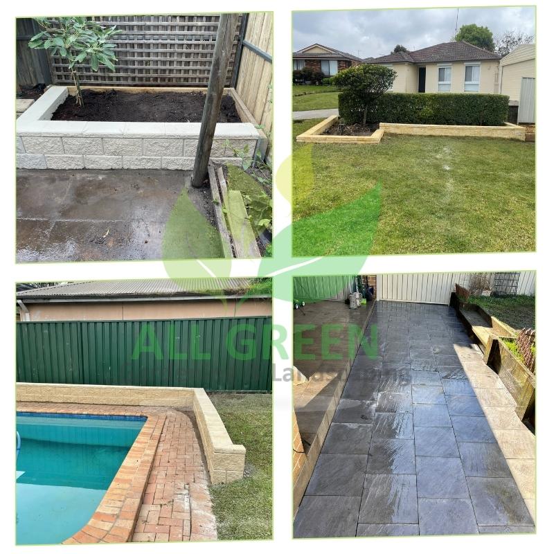
When in search of a local landscaper, people often use “Landscaper near me”. Yes, it’s us! We provide landscape garden maintenance services, covering retaining walls, outdoor space design, garden planning, and full landscaping projects.
Curl Curl’s Best Landscaping Company Is Here
Whether your project is substantial or minor, we provide affordable, quality landscape design services. Choose us for structural landscaping—a complete solution by our skilled team.
We’re your local option for budget-friendly services, backed by our Best Price Guarantee!
Experience the pinnacle of NSW landscaping with All Green Gardening & Landscaping. Our commitment to paving, tree removal, and more promises gardens of grandeur. Add tangible value and aesthetic to your property. Embark on a transformation; choose us.
We also serve and have landscaping projects in the following surrounding suburbs:
The All Green Gardening & Landscaping Difference:
- Service Spectrum: From mulching to tree removal, our proficiency covers every garden aspect.
- Elevate Your Property: With us, watch your property transform and its value rise.
- Custom Touch: We design solutions based on your garden’s unique essence.
- Eco-Centric: We’re all about green, sustainable gardening that benefits the environment.
- Excellence Assured: Trust our experienced landscapers to surpass your expectations.
- Dedicated to You: With a focus on client satisfaction, we aim to exceed in both service and communication.
Curl Curl Landscaping Services by All Green Gardening & Landscaping
At All Green Gardening and Landscaping, we’re skilled at creating exceptional, eco-friendly environments that enhance both residential and commercial spaces through thoughtful landscape design. Keep in the loop by following our Facebook Page. Whether it’s small-scale backyard landscaping in Curl Curl or a more extensive project, our focus remains on delivering top-notch customer service and professional landscaping solutions in Curl Curl. We’re your go-to for residential and commercial landscaping, in partnership with our expert designers and installers.
Trust our licensed landscape designers for superior designs on your extensive projects. We begin with a site consultation. Our designers will sit down with you to understand your project and the necessary work. Once we have done this we will provide you with a fully detailed consultation for your landscape design which will include a professional plan of the area and a planting plan and it will incorporate all aspects of the garden layout.
Why Trust All Green Gardening & Landscaping? ⭐
Since 2010, we’ve been your trusted source for exceptional landscaping in Curl Curl. Your satisfaction is our priority, and we guarantee it with our gardening and landscaping services, providing peace of mind.
Our name is the go-to choice for the Best Landscaper Nearby, all thanks to the exceptional services delivered by our experienced landscapers.
Our Services
Best Turf Laying Solutions in Curl Curl
Hassle-Free Turf Laying Services in Curl Curl by All Green Gardening Services. Importantly, turf laying can be a complex process that requires proper preparation and installation. Here at All Green Gardening Services, we make the process smooth and hassle-free. To put it simply, excellence is just a phone call away.
Top-Quality Mulching Services: Best in Curl Curl, NSW
Embrace the magic of premium mulching with All Green Gardening & Landscaping. Our expertise ensures gardens inCurl Curl, NSW 2096 flourish, benefiting from enhanced moisture, reduced weeds, and enriched soil. Let us redefine your landscaping experience.
Our Paving Curl Curl Experts
For the best pavers in Curl Curl, look no further than All Green Gardening and Landscaping!
Need a Retaining Walls Curl Curl Team
We are dedicated to offering Curl Curl residents premium panel and post concrete retaining walls, a cost-effective alternative to brick and limestone.
Expert Tree Services inCurl Curl
Dive into the world of superior tree care with All Green Gardening & Landscaping. ServingCurl Curl, our services range from trimming to full-scale removals, all done with utmost precision. Trust us for a greener, safer outdoor space.
Top-Tier Weeding Services in Curl Curl
All Green Gardening & Landscaping takes pride in providing Curl Curl with premium weeding services. Our team guarantees a garden where desired plants flourish unhindered. Embrace a garden free from invasive growth with our expert touch.
Reliable Landscaping Services in Curl Curl NSW 2096
Frequently Asked Questions
{We offer a comprehensive range of landscaping services, including garden design, lawn maintenance, tree and shrub care, hardscape construction, irrigation system installation, and more. | From garden design to tree care and irrigation installation, our landscaping services are comprehensive and tailored to your needs.
Through landscaping services, we strive to augment your property’s visual charm, constructing alluring, well-maintained outdoor areas that raise curb appeal and property worth.
Our specialty is creating personalized landscaping solutions that transform your outdoor space into your dream vision.
Current Landscaping Jobs in Curl Curl
Calling all experienced Local Landscapers in Curl Curl! Same-day jobs await – apply through email.
[justified_image_grid row_height=800 height_deviation=0 overlay=off use_timthumb=no disable_cropping=yes flickr_search_text=Curl Curl-NSW max_rows=4 flickr_search_sort=popular]